


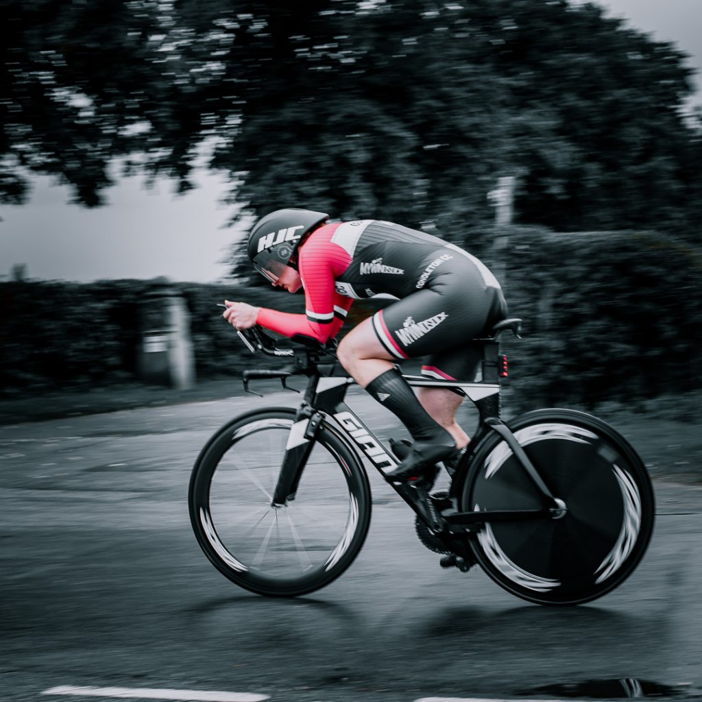
Cyclists often daydream about conquering impressive mountains, inspired by professionals navigating legendary ascents in major races. Our goal, among many, is to help you explore the world’s iconic cycling segments, find the best day and give you the information you need to snipe the KOM .
Based on thorough research (some Googling and asking around), we present our initial list of four of the UK’s Strava Classic Segments. myWindsock is perfect for segment whacking on Strava! All segments are available to view in the app.
In this context, a classic segment is defined by historical significance. Exploring the study of past events, especially in human affairs, unveils narratives tied to these climbs. Our aim is to traverse routes that have witnessed the achievements of cycling heroes.
Another defining criterion is difficulty. The challenging nature of these segments is embraced by great cyclists who understand the value of enduring hardship. Conquering notoriously tough segments strengthens resilience, providing a sense of triumph upon reaching the summit. We do not include any easy segments here – sorry to the fans of Surrey who were expecting Box Hill to make another undeserved list of climbs or segments in the UK.
Without further ado, we present the preliminary roster of Strava Classic Segments, each embodying the rich history, challenging difficulty, and picturesque scenery that characterise these iconic cycling challenges:
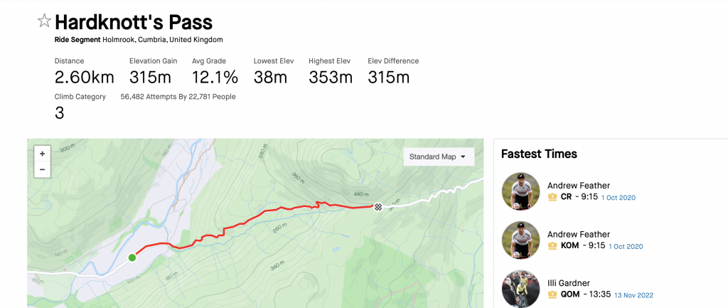
Riders navigate a narrow, single-track road extending from Eskdale in the west to the outskirts of Wrynose Pass in the east, offering an experience of both challenge and scenic views. On the western side, Harter Fell stands tall, accompanied by the remnants of Hardknott Roman Fort at 660 feet (200 meters) above sea level.
The Hardknott Pass, reaching a maximum elevation of 393 meters, leads to a steep descent with a gradient of 30% (1 in 3) into the Duddon Valley. At the eastern end of the pass, you’ll find Cockley Beck farm, built in the 1860s and owned by the National Trust. The route from Hardknott extends eastward, guiding cyclists toward Wrynose Pass and Ambleside.
Recognised as one of the more demanding cycling routes in Britain, Hardknott Pass features a series of challenging hairpin bends, often affecting visibility. The road surface is known for its poor condition. Winter closures are common due to impassable icy conditions. Following the Highway Code, ascending traffic (including cyclists) should given priority.
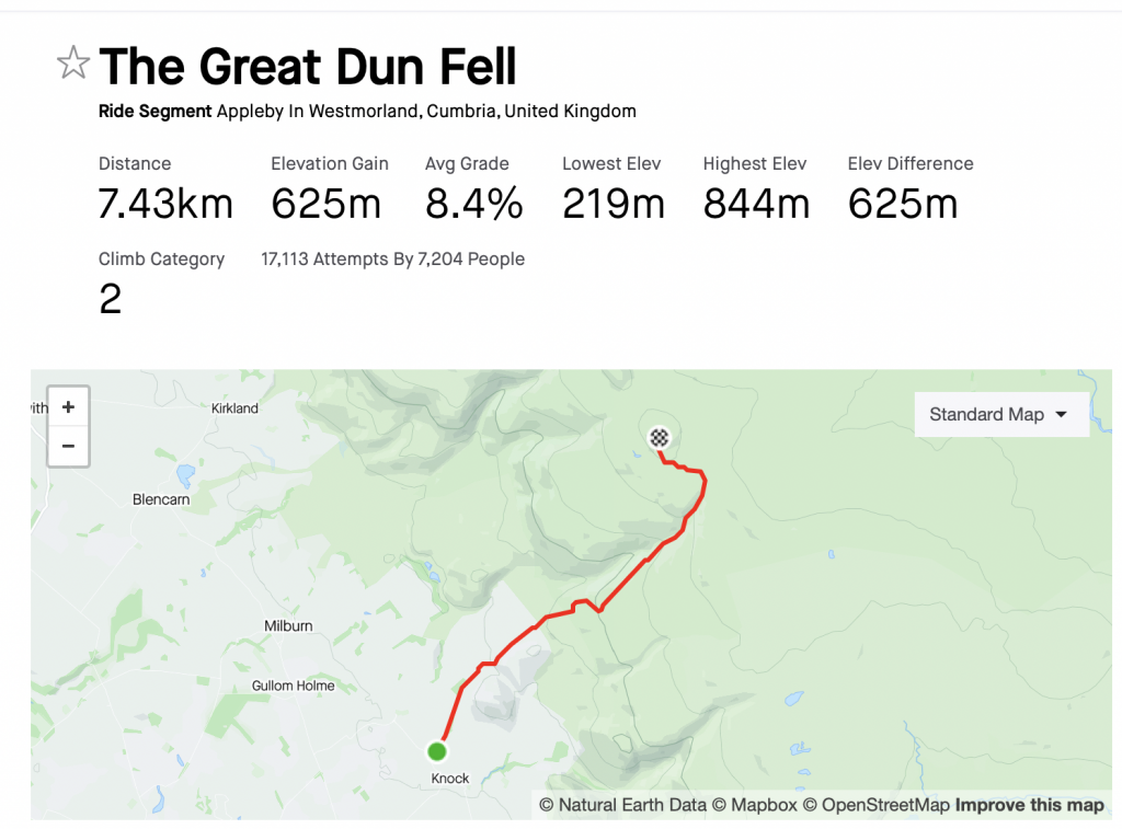
Great Dun Fell, standing at 848 meters (2,782 ft), is the second-highest peak in England’s Pennines. Positioned two miles (3.2 km) south along the watershed from Cross Fell, its higher neighbor, it, along with Little Dun Fell (reaching 842 m or 2,762 ft), serves as a landmark on the Pennine Way’s ascent from Dufton. Located within the historical county boundaries of Westmorland, it falls within the ceremonial county of Cumbria and the modern unitary authority area of Westmorland & Furness.
The climb itself is a long one gaining over 600 meters of elevation as you ride up. In order to take the KOM a rider must maintain a VAM of over 1600m/hr – this is perhaps slightly more achievable for more riders, at least compared to Feather’s time up Hardknott. EF Education’s Lizzie Banks holds the QOM.
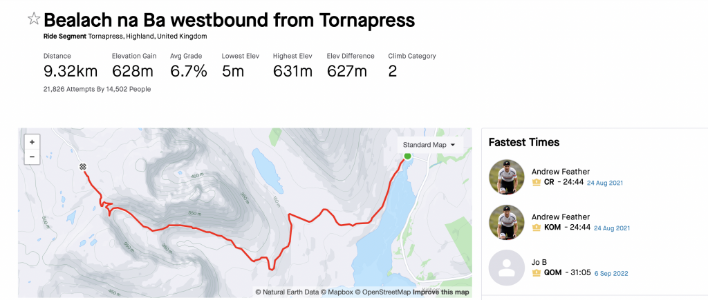
Bealach na Bà is a winding single track road through the mountains of the Applecross peninsula in Wester Ross, Scottish Highlands. The Bealach na Bà is just one feature on this road, being its highest point and site of several corries.
The historic mountain pass was built in 1822 and is engineered similarly to roads through the great mountain passes in the Alps, with very tight hairpin bends that switch back and forth up the hillside and gradients that approach 20%. It has the greatest ascent of any road climb in the United Kingdom, rising from sea level at Applecross to 626 m (2,054 ft) in about 6 km (3.7 mi), and is the third highest road in Scotland. In typical fashion, the segment is longer than the ‘climb’ with a false flat “fake news climb” couple of km at 1-3%.
The name is Scottish Gaelic for “Pass of the Cattle”, as it was historically used as a drovers’ road. The road is so steep, twisty and windy that learner drivers are encouraged not to drive up it. How anyone ever drove cows up here is completely beyond us but we can be sure they didn’t do it as fast as Feather who, once again, seems to have the KOM…
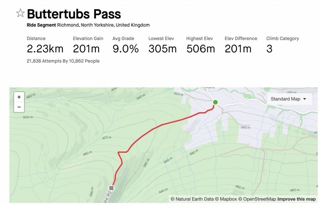
The Buttertubs Pass, situated in the Yorkshire Dales, England, is a high road that winds north from Simonstone near Hawes to Thwaite and Muker, passing by 20-meter-deep limestone potholes known as the Buttertubs. Legend has it that farmers, en route to market, would rest there and, during hot weather, lower the butter they had produced into the potholes to keep it cool.
Locally recognised as a challenging climb, the road gained prominence as the second and highest of three categorised climbs in Stage One of the 2014 Tour de France. German cyclist Jens Voigt led the race over the climb, earning the polka dot jersey as the leader of the mountains classification.
I bet you can’t guess who has the KOM…
myWindsock allows you to check out any Strava segment, just star it and then plan your assault on the segment. Next week we will do a step by step guide on trying to take a Strava segment making use of myWindsock, Strava and a live segment head unit feature all at once.
If you want to get the best out of your segment whacking, sign up to myWindsock here.